Introduction
Iford Playing Fields has long served as a beloved riverside green space for the people of Dorset — a place for families, walkers, cyclists, nature‑lovers and sports enthusiasts to enjoy the serenity of the River Stour. Its gentle paths, lush vegetation and river views made it a cherished community asset.
But in late May 2025 (local reports suggest between May 27–29), a substantial section of the riverbank suddenly gave way. Trees, soil, and even sections of path collapsed into the river overnight. The familiar riverside green transformed almost immediately into a hazard zone. Suddenly, a place of recreation became a zone of danger — raising urgent questions about safety, environmental damage, and long‑term land management.
This article offers a complete, science‑grounded, community‑aware and future‑oriented overview of the collapse. We explore what triggered it, what’s already been lost, how local authorities and residents have responded — and most importantly, what must be done to restore and safeguard Iford Playing Fields for future generations.
Understanding Riverbank Collapse
What is a riverbank collapse?
A riverbank collapse happens when the structural integrity of a riverbank fails — causing soil, vegetation, and sometimes infrastructure to slide or slump into the river. While rivers constantly reshape their banks through natural erosion and deposition, collapse represents a catastrophic failure: the bank goes from being stable to unstable, often suddenly.
In many cases, what appears as a sudden collapse is actually the endpoint of a long‑term weakening process. Erosion at the base of the bank (the “toe”), gradual loss of vegetation, repeated soil saturation, footpath compaction and human pressures can all combine — until one final trigger (e.g., heavy rain, flood surge, wind) causes the bank to give way.
Why erosion alone doesn’t always lead to collapse — until it does
Erosion is a natural, slow process: over years, a river slowly eats into its bank, especially on bends where flow is stronger. Soil and vegetation may hold up fine for decades. However, when the balance between erosive force and bank resistance tilts — due to increased flow, weakened soil cohesion, or loss of root support — the risk of slope failure increases significantly.
In other words: erosion and collapse are related but distinct phenomena. Collapse isn’t inevitable — but it becomes far more likely when multiple stressors accumulate.
Causes of the Collapse at Iford Playing Fields
The collapse at Iford appears to be the result of a confluence of natural processes and human‑driven pressures. While a single trigger (heavy rainfall and soil saturation) may have set it off, underlying vulnerabilities had developed over years.
Heavy rainfall and soil saturation
In the weeks leading up to the collapse, the region reportedly experienced unusually heavy rainfall. Soils along the River Stour — particularly floodplain soils rich in silt and fine sediments — absorbed large volumes of water. Saturated soils lose shear strength: pore-water pressure builds up, cohesion drops, and the soil becomes heavier and more likely to slump. effects, in the case of partially tidal rivers), banks have less drainage and more hydrostatic pressure — a dangerous scenario for stability.
Toe erosion (hydraulic undercutting) and river dynamics
One of the most common technical causes of bank failure is toe erosion. Flowing water scours away the base of the bank over time, gradually undercutting the soil mass above. As that support erodes, the overlying soil loses its base and eventually collapses under its own weight.
In the stretch near Iford — reportedly near a bend by a bridge — water flow is likely stronger, increasing the rate of undercutting. Over years, this could gradually hollow out the bank in a way not obvious to casual observation — until collapse becomes unavoidable.
Vegetation loss and weakened root support
Vegetation — especially deep‑rooted trees and shrubs — plays a critical role in bank stabilization. Roots anchor soil, bind sediments, and reinforce the slope against slumping. When vegetation is removed (for paths, recreation, aesthetic lawns) or ages/decays naturally, that root “reinforcement” disappears, weakening the bank’s resistance to erosive and hydraulic forces.
Local accounts suggest that at Iford, some sections of the bank may have been maintained as open lawns or playing fields — a use that tends to encourage mowing, soil compaction and removal of deep‑rooted plants. Over time, this likely compromised bank stability.
Human activity, footpath compaction, and drainage issues
Foot traffic (walkers, cyclists, dog‑walkers), repeated mowing, and compaction near the riverbank all contribute to the vulnerability. Compacted soil drains poorly, retains water, and offers little friction — making slumping easier when saturated. Furthermore, drainage infrastructure (if poorly designed or blocked) can concentrate surface water or discharge directly at vulnerable bank sections, accelerating erosion.
In some reports, the proximity of a railway bridge and possible drainage/discharge near that area is mentioned as an aggravating factor. While it’s speculative, infrastructure near rivers often affects flow patterns and bank stress.
Extreme weather and climate trends
Experts emphasise that what may once have been “rare” flood or heavy‑rain events are becoming more frequent. In many UK river systems — including the Stour catchment — this increased variability and intensity of rainfall, combined with unstable soils and human pressures, raises the baseline risk of bank failure.
When heavy rainfall, saturated soil, strong winds (which can stress tree roots), and elevated river levels combine, the conditions become ripe for sudden collapse. Iford’s collapse seems to reflect exactly such a “perfect storm.”
Signs of Riverbank Instability — What to Watch For
Before a collapse occurs, banks often show warning signs. The collapse at Iford reportedly followed some of these indicators.
- Cracks in footpaths or soil surfaces near the bank — often widening over time.
- Slumping or sagging of bank edge, where the soil appears to droop or lean toward the river.
- Murky water or sudden increase in sediment after rain — indicates soil and debris washing into the river.
For many locals, these signs may seem minor — a bit of cracking, a leaning tree — but together they can point to serious, accumulating risk.
Immediate Impacts of the Collapse
The collapse at Iford Playing Fields triggered several immediate and observable consequences — affecting public safety, recreation, environment, and local infrastructure.
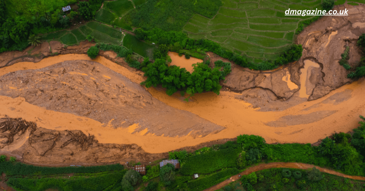
Damage — Trees, Paths, and Infrastructure
Eyewitness and community reports describe large trees uprooted and submerged, soil gone, and a formerly gentle slope turned into a steep drop beside the river. Fences, benches, and sections of footpath “either slid into the river or ended perilously close to the new edge.”
Such damage reduces the amenity value of the fields instantly: the shady trees, riverside benches, and safe walking paths that once drew families and dog‑walkers are gone or unsafe.
Public Safety Risks & Restricted Access
The collapse created a dangerous scenario for anyone using the riverside paths: a steep drop, unstable soil, hidden undercuts. Without delay, local authorities — mostly BCP Council — reportedly cordoned off the most hazardous sections. Warning signs and fencing were erected to prevent accidents.
Even areas that appear stable may conceal compromised soil. The risk isn’t just of falling — there’s also risk of additional, unexpected slumping. Until a full geotechnical assessment is completed, the safest approach is to treat the entire collapsed and surrounding zone as unstable.
Short‑Term Disruption to Community Use
For residents, the loss of accessible riverside paths and green spaces can be jarring. Families, walkers, cyclists, and sports clubs — many of whom relied on Iford for recreation — found their routines disrupted. Some local businesses or clubs that benefit from footfall may have seen a decline.
Beyond convenience, many local visitors reportedly felt shock and sadness — grieving not just lost amenities, but lost memories: picnics by the water, dog walks, kids playing near the riverside.
Environmental and Ecological Consequences
The collapse didn’t just damage recreational features — it also disturbed the ecosystems tied to the River Stour and its riparian zones.
- Bank vegetation lost: Mature trees and shrubs uprooted during collapse remove root networks that stabilize soil — making future erosion more likely.
- Increased sediment runoff: Large volumes of soil, silt, and organic matter entered the river, likely elevating turbidity, interfering with photosynthesis, and potentially smothering spawning grounds or aquatic vegetation.
- Habitat disruption: The riparian belt — home to birds, insects, small mammals, amphibians — lost both cover and nesting grounds. Fallen trees may alter flow, change habitat structure, or create debris dams.
- Water‑quality impacts: Increased sediment, potential nutrient release from disturbed soils, and loss of shading (leading to warmer water) may affect aquatic life and overall water health.
In sum: the collapse immediately degraded both human amenity and ecological integrity.
Expert Analysis and Technical Insights
To understand why the collapse happened — and to design effective restoration — it’s important to look at technical factors: hydrology, soil mechanics, geomorphology, and human influence.
Hydraulic Undercutting and Toe Erosion
As water flows downstream, it exerts shear stress against the base (toe) of the riverbank. Over time, sediment is washed away — a process called scour or toe erosion. If sediment removal outpaces natural deposition (or bank protection), the base erodes away, leaving the bank unsupported.
In a gently flowing river this process is slow. But in a curved channel, near a bridge (where flow velocity may increase), or in tidal or backwater‑influenced stretches, the erosive force intensifies. This may explain why the collapse occurred at the particular stretch of the bank near Iford — reportedly near a bridge and bend.
Soil Saturation, Pore‑water Pressure, and Shear Strength Loss
Soil strength depends on cohesion between particles and the frictional resistance between them. When soils become saturated, water fills pore spaces and reduces friction and cohesion. The soil becomes heavier, more plastic, and much more likely to fail — especially on slopes.
Persistent rainfall and high groundwater levels, especially combined with tidal effects or poor drainage, dramatically increase this risk. The 2025 collapse at Iford appears to have occurred precisely after such a period.
Loss of Root Reinforcement — Vegetation as Natural Stabilizer
Roots of deep‑rooting shrubs and trees penetrate soil, bind particles, and reinforce slopes — acting like natural reinforcement bars. Their removal or decay weakens the bank’s structural stability. In riverside zones maintained as lawns or recreation areas, the replacement of deep-rooted vegetation with shallow‑rooted grass removes that natural reinforcement.
In addition, mature trees near the bank — once roots fail due to undercutting — can themselves cause collapse: as the tree topples or is pulled by winds, large soil masses can be dragged into the river. That seems to have happened at Iford.
Human Impact: Footpaths, Compaction, Drainage & Infrastructure
Repeated human activity — walking, cycling, dog‑walking, maintenance — compacts soil and can change its structure. Compacted soil drains slowly, accumulates water, and loses natural porosity — conditions that make saturation and failure more likely. Additionally, drainage systems, path construction, or nearby infrastructure (like bridges) can concentrate runoff and change flow patterns, putting extra stress on vulnerable riverbanks.
In short, natural systems that might have adapted over centuries have been destabilized by repeated human use and unmanaged maintenance.
Climate Change & Increased Frequency of Extreme Weather Events
Over recent decades, the UK (like many regions) has seen a shift in rainfall patterns — more frequent heavy downpours, flash floods, unpredictable weather. These trends stress river systems and floodplains that were designed (or evolved) for less extreme variability.
A collapse like that at Iford may therefore be a symptom of a changing climate: what might previously have been a rare 1-in-50-year event may now occur more frequently, especially if banks remain unprotected.
Community Reaction and Local Involvement
The collapse at Iford Playing Fields has stirred a range of reactions — from shock and grief to concern and resolve. For many, it’s more than environmental damage: it’s a loss of place and memory.
Local residents reportedly described the event as deeply upsetting: regular dog‑walkers, families, and people who used the fields for recreation said discovering fallen trees and a jagged riverbank felt like losing a small part of their community.
On social media and community forums, many questioned whether warnings had been ignored — whether signs of instability (erosion, cracks, leaning trees) had been dismissed. Some expressed frustration with lack of earlier action; others called for calm, reasoned response and long-term solutions.
On the more hopeful side — the incident has galvanized interest. Conservation groups, volunteers, and concerned residents are discussing replanting, monitoring, and helping ensure the bank is restored safely and sustainably. There’s a growing sense that this crisis could become an opportunity: to rebuild more resilient, ecologically healthy riverbanks — and involve the community in stewardship.
Response from Authorities
Recognizing the urgency, local authorities responded quickly. The collapse was assessed by engineers and environmental
Emergency Safety Measures
Within days of the collapse, council teams cordoned off the most dangerous sections, erected warning signs, and restricted public access.
This immediate response likely prevented accidents — especially given that the collapse created a steep, potentially unstable bank edge, hidden undercuts, and submerged debris.
Assessment and Planning
Officials reportedly commissioned preliminary surveys — including topographical observations, soil stability checks and hydraulic assessments — to evaluate the extent of damage and risk of further collapse.
Longer-term restoration planning is being considered, involving both engineering and ecological expertise. The aim: not just to patch the bank, but to rebuild in a way that’s safe, sustainable, and supportive of wildlife.
Collaboration with Environmental Experts
Rather than defaulting to hard engineering (e.g., concrete walls), authorities are reportedly open to soft‑engineering and bioengineering — integrating ecological restoration and bank stabilization. This suggests an understanding that riverbank restoration must balance human and environmental needs.
Restoration and Recovery Efforts
Restoring Iford’s riverbank requires a careful, phased, and interdisciplinary approach — balancing public safety, ecological resilience, and community values. Based on best practices and local reporting, the likely roadmap involves the following stages.
Short‑Term Stabilization & Remediation
Immediately:
- Clearing dangerous debris and fallen trees that pose a hazard or obstruct flow.
- Installing temporary stabilization — soil mats, coir rolls or brushwood mattresses along the bank edge to reduce further erosion.
- Redirecting path drainage away from the riverbank to prevent concentrated flow toward vulnerable zones.
- Erecting temporary barriers, signage, and redefining safe public access routes until the bank is secured.
Medium‑Term: Bioengineering & Ecological Restoration
Rather than building rigid walls or armour, local authorities — working with ecologists and geomorphologists — plan to implement naturalistic bank stabilization:
- Planting native, deep‑rooting trees and shrubs (e.g., willows, alders) whose roots help bind soil and resist erosion.
- Installing live‑stake systems, fascines (bundles of live branches), brushwood mattresses or coir rolls — natural materials that stabilize soil while providing habitat
- Regrading slopes to gentler angles to reduce slope stress, improving drainage, and encouraging vegetative growth.
- Using fallen wood (where safe and ecologically appropriate) as “large woody debris” in the river to increase habitat complexity, create flow refuges for fish, and reduce erosive energy — provided it’s anchored properly.
Long‑Term Monitoring & Maintenance
Bank recovery is not instantaneous. Even after planting and stabilization:
- Regular inspections (especially after storms) to detect signs of new erosion, slumping or undercutting.
- Maintenance of planted vegetation — watering, protection from trampling, management of invasive species.
- Adaptive drainage management — ensuring surface water and runoff do not concentrate at vulnerable points.
- Community engagement — volunteer planting days, citizen monitoring of bank condition, reporting early warning signs.
Preventing Future Riverbank Collapses — Lessons from Iford
The collapse at Iford is a wake‑up call. It underscores the need for proactive, integrated riverbank management — combining engineering insight, ecological understanding, and community involvement.
Here are key lessons for Iford and other similar communities:
- Prioritize natural stabilization over hard engineering where possible. Bioengineering solutions often succeed long-term, preserve habitat, and are more sustainable than concrete walls.
- Promote deep‑rooted vegetation along riverbanks. Replace shallow lawns or compacted grass near the edge with native shrubs/trees that bind soil.
- Maintain safe setback distances for footpaths and recreation areas. Avoid locating heavy foot traffic or infrastructure too close to vulnerable zones.
- Ensure proper drainage and runoff management. Redirect surface water away from banks; avoid discharging drainage directly at bank toes.
- Monitor riverbanks regularly. Early detection of cracks, slumps, root exposure, soil compaction or drainage problems can allow preventive action before collapse.
- Engage the community. Crowd‑sourced monitoring, volunteer planting, and public awareness help build stewardship and prevent neglect.
- Factor climate change into planning. As heavy rainfall and storms become more frequent, riverbank designs must anticipate higher stress and increased erosion risk.
- Adopt adaptive management: treat riverbanks as dynamic systems. Allow flexibility, periodic assessment, restoration, and adaptation rather than static “set-and-forget” fixes.
Public Safety and Visitor Guidance
Until restoration is complete, visitors to Iford Playing Fields should be cautious:
- Avoid fenced-off or cordoned areas. Do not try to bypass barriers or explore near the scarp edge — soil may be unstable beyond visible cracks.
- Follow official signage, warnings, and diversions. Paths may change; cycle routes or walking tracks may be temporarily closed or re-routed.
- If you notice new cracks, slumping soil, leaning trees, or muddy/rusty water flow — treat as a hazard and report to local authorities (e.g., BCP Council or local environmental agency).
- Avoid swimming, wading, or paddleboarding near the collapsed bank — submerged roots or debris may pose hidden dangers.
- For families, keep dogs and children away from the river edge until the area is declared safe.
Restoration may take months to years. Patience, cooperation, and community vigilance will play a big part in ensuring a safe and ecological recovery.
Broader Context — What Iford Tells Us About UK Riverbank Risks
The Iford collapse may feel like an isolated tragedy — but it’s part of a larger pattern facing many UK rivers and floodplain green spaces.
- Across the UK, riverbank collapses and erosion events have increased — driven by changing rainfall patterns, urban encroachment, and legacy land‑use practices.
- Recreational green spaces, often developed decades ago without detailed understanding of river dynamics, are especially vulnerable. Walking paths, playing fields, and manicured lawns near rivers tend to ignore long‑term bank stability.
- Natural flood management (NFM) and eco‑engineering are becoming central to national and local strategies — recognizing that hard concrete embankments often do more ecological harm than good.
- Climate change — unpredictable rains, more frequent storms, rising groundwater, tidal backwater effects — means what was once “safe” may no longer be so. Communities and councils must adapt proactively.
Iford is, in many ways, a case study — a microcosm of the challenges facing many riverside green spaces across the UK.


Leave a Reply